Geolocation in OSINT: Techniques, Challenges, and Applications
Geolocation is a vital component of Open Source Intelligence (OSINT), allowing investigators to determine the physical location of an object or person through various data points such as images, videos, and social media posts. This technique is essential for numerous applications, including verifying information, tracking activities, and enhancing situational awareness.

Key Techniques in Geolocation
Image Analysis:
Investigators analyze images to identify landmarks, street signs, and natural features. This process often involves cross-referencing visual cues with online maps and satellite imagery to pinpoint locations. For instance, unusual features like specific architectural styles or natural formations can significantly narrow down the search area.
Metadata Examination:
Digital files often contain metadata that can provide location information. EXIF data in images, for instance, can reveal the coordinates where a photo was taken. However, this data can be manipulated or stripped, so it's crucial to corroborate metadata with other evidence.
Social Media Scrutiny:
Social media platforms are rich sources of geolocation data. Users frequently share posts with location tags or recognizable landmarks. By analyzing user posts, photos, and check-ins, investigators can triangulate a subject's location. Tools like geotagging applications and social media monitoring software enhance this process.
Cross-Referencing Data:
Effective geolocation often requires cross-referencing multiple data sources. This can include combining satellite imagery with social media analysis, using weather data to match environmental conditions in photos, and employing historical data to understand changes in the landscape.
Public Databases:
Online platforms often offer information regarding businesses, addresses, and individuals. Various public databases provide access to this information, which can be valuable for geolocation purposes.
IP Address Geolocation:
The geolocation of an IP address can provide an approximate location of a device or user. OSINT analysts might utilize tools to trace IP addresses and estimate their geographical locations.
Communication and Network Data:
Analyzing communication patterns and network data can reveal device locations through network traffic patterns.
Geospatial Analysis and Intelligence
Geospatial analysis involves collecting, displaying, and utilizing visuals, GPS data, satellite imagery, and historical information described either explicitly by geographic coordinates or implicitly by addresses or identifiers. Geospatial intelligence (GEOINT) is the assessment and analysis of physical characteristics and geographical activity using geolocation images and information. This method is essential for understanding and responding to global incidents such as pandemics and natural disasters.
Practical Applications
Verification of Information:
Geolocation helps in verifying the authenticity of information. For example, during conflicts, verifying the location of videos or images shared online can validate or debunk claims made by various parties.
Search and Rescue Operations:
Geolocation aids in locating missing persons by analyzing digital footprints left behind through social media and other online activities.
Law Enforcement and Security:
Authorities use geolocation to track criminal activities, monitor suspects, and gather evidence. It also plays a crucial role in counter-terrorism by identifying the locations of terrorist cells and their activities.
Journalism and Human Rights Investigations:
Journalists and human rights organizations use geolocation to investigate and report on incidents in conflict zones or areas where access is restricted. It helps in verifying the location of events and ensuring accurate reporting.
Challenges in Geolocation
Data Manipulation:
Metadata can be altered, and images can be edited to mislead investigators. This necessitates the need for thorough cross-verification using multiple sources.
Rapidly Changing Environments:
Urban development and natural changes can alter landscapes, making it difficult to match current images with older satellite or map data.
Technological Barriers:
High-resolution images and sophisticated software tools are often required for precise geolocation, which can be resource-intensive.
Privacy Concerns:
The use of geolocation tools raises privacy issues, especially when tracking individuals without their consent. It's important to balance investigative needs with ethical considerations.
Methods of Geolocation OSINT
Geolocation OSINT encompasses various methods, but six commonly used techniques stand out:
Social Media and Online Presence:
Individuals often share location information on social media platforms, including photos and check-ins.
Metadata from Images:
Photos often contain metadata that reveals when and where they were taken.
Public Databases:
Online platforms and public databases provide valuable information about businesses, addresses, and individuals.
Mapping Services:
Maps and mapping services are essential tools for geolocation, helping to analyze and combine information to pinpoint locations.
IP Address Geolocation:
Geolocating an IP address provides an approximate location of a device or user.
Communication and Network Data:
Analyzing network data can reveal device locations through traffic patterns.

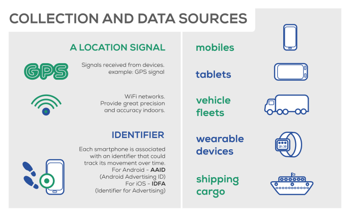
With the advancement of computer devices, mobile communications, and social media platforms, tracing people's geolocation details has become increasingly popular. Various electronic equipment now has satellite tracking sensors to detect their exact position, and most portable technologies are now aware of their surroundings. Additionally, many programs, internet services, and social media platforms can monitor a user's whereabouts in some way.
Geolocation and Chronolocation
Geolocation involves identifying the specific location where an image was taken, while chronolocation focuses on determining the time it was captured. Both techniques can provide valuable context and help verify the authenticity of images. Here are some methods to improve your geolocation and chronolocation skills:
Identifying Landmarks and Other Geographical Features: Examining an image for distinctive elements such as buildings, monuments, or natural formations can help narrow down the location. Cross-referencing these features with maps, online databases, or local knowledge can lead to accurate geolocation.
Analyzing Shadows and Light Sources: Shadows and lighting in an image can offer clues about the approximate time the photo was taken. By understanding how the sun's position changes throughout the day and considering factors like daylight saving time, you can make educated guesses about the time of day when the image was captured.
Cross-Referencing with Maps and Satellite Imagery: Tools like Google Maps, Bing Maps, and Google Earth can be invaluable for verifying locations and finding additional visual data. Satellite imagery can also reveal changes over time, helping you pinpoint when an image was taken.
Conclusion
Geolocation is an indispensable tool in the OSINT toolkit, offering the ability to uncover and verify information through the physical location data embedded in digital content. By combining various techniques and tools, investigators can achieve high levels of accuracy in their findings, supporting a wide range of applications from law enforcement to humanitarian efforts. However, the challenges and ethical considerations must be carefully managed to ensure the responsible use of geolocation technology.